

Whatever new drone photography skill you want to learn, there’s an app for it. Whether that's planning a shoot, flying it, or working out which ND filter to fit, there are a lot of drone apps. The hard part is knowing which ones are still worth installing.
The drone app landscape has changed a lot. Several of the apps that used to top lists like this one have shut down completely. And since DJI closed its Mobile SDK to new drones, the third-party apps that fly your drone for you only work with certain models.
So we've rebuilt this list from scratch. Every app below is live and available now, and we checked each one against its own App Store and Google Play listing in August 2026. We've ranked them from 10 up to 1, and flagged exactly which drones each one works with.
If you only install two, make them the app that flies your drone and an FAA-approved airspace app. For most people that's DJI Fly at number 1 plus AutoPylot at number 8 if you fly in the US, or Aloft Air Aware at number 9 if you travel. Everything else on this list earns its place after those two.




10. Airdata UAV

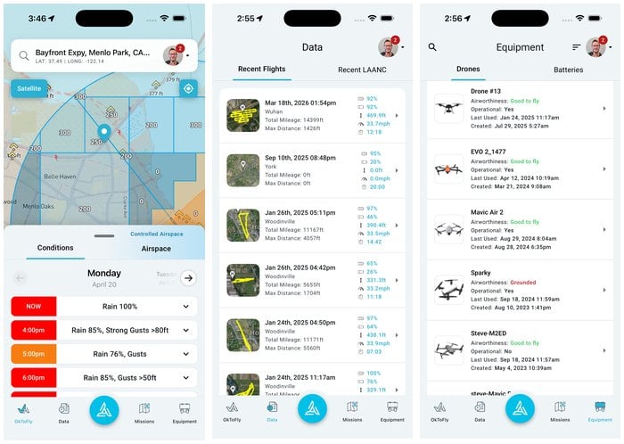
Every flight your drone makes writes a log file. Airdata UAV reads them.
Connect it once and it pulls in your flights automatically, then turns them into something you can actually use. You get flight replays on a map, battery health reports across every cell, signal-strength graphs, and warnings when a battery is starting to degrade.
It is not a flying app, so you won't open it at the launch site. But it is the app that tells you why a flight felt wrong, and it builds the flight record you need if you ever start a drone photography business.
The free tier covers most hobby pilots. Paid plans add more storage and deeper reporting.
9. Aloft Air Aware
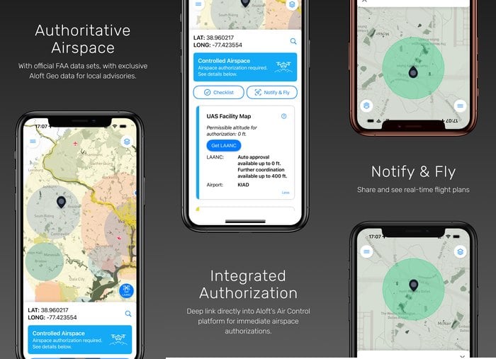
Air Aware answers one question fast: can I fly here, right now?
Open it and you get a map of the airspace around you, with the restrictions, advisories, and warnings that apply to your spot. It pulls in weather at your location too, so you can see whether the wind and cloud are going to cooperate.
It earns a place over the many apps that do something similar because of the data behind it. Aloft is one of only five companies the FAA approved to deliver B4UFLY, and Air Aware pairs that official US data with Aloft's own set of local drone rules from around the world. So it still has something to tell you when you travel with a drone outside the United States, which is where most airspace apps go quiet. It also maps FRIA sites, the FAA-recognized areas where you can fly without Remote ID.
Think of this as the quick check before you unfold the props. For anything more involved, its bigger sibling is at number 4.
8. AutoPylot
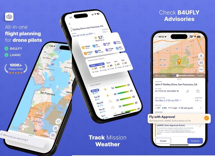
If you fly in the United States, you need to know where the Federal Aviation Administration (FAA) lets you go.
The FAA used to publish its own B4UFLY app. It doesn't any more. The service now runs through a handful of approved companies, and AutoPylot is one of them. So the airspace data you get here is the official B4UFLY data, in an app that is still being developed.
It is free. You get the airspace map, LAANC authorization requests for controlled airspace, weather, and pre-flight checklists. For a recreational flyer in the US, that is genuinely everything you need to stay legal.
It is built around US airspace rules, though. Take it abroad and it has nothing to say about where you are standing, which is the gap Air Aware fills.
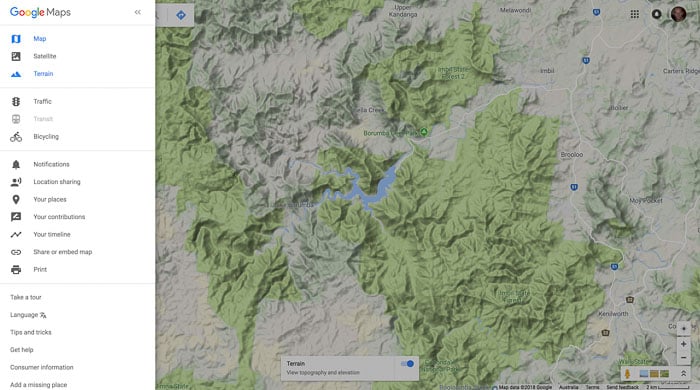
7. Google Maps
As an obsessive photo-planner, I count Google Maps as one of my best friends.
It's useful for many tasks, including finding drone photo locations and working out the best places to launch from. It also measures distances and, of course, gets you there.
This is often the first place I go. Especially when I'm looking for compositions you would never be able to see from the ground. I spend hours scouring Google Maps and saving locations that have the potential for great drone landscape photos.
The topographical map in Terrain Mode is a great help for reading the contours of the landscape before you arrive.
What it will not tell you is whether you are allowed to fly there. There is no airspace layer in Google Maps, so a spot that looks perfect on satellite view can sit inside controlled airspace. Use it to find the shot, then use one of the airspace apps above to clear it.
6. UAV Forecast
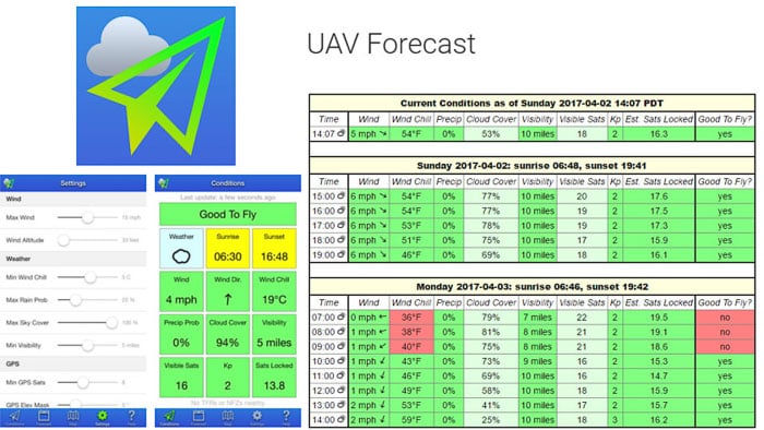
If you want a drone app that gives you real detail about the weather, UAV Forecast is it.
You punch in the specifications of your drone, and it tells you whether conditions are safe to fly or not. Wind speed, wind direction, temperature and chill, cloud cover, visibility, and the chance of rain.
It also covers the two things general weather apps never mention: the number of GPS satellites you'll be able to lock onto, and the Kp index, which tells you whether geomagnetic activity is likely to upset your drone's compass.
The app is free, and a subscription extends the hourly forecast out to 24 hours, 7 days or 15 days. It's what I check the night before a shoot.
5. Litchi
Litchi is the app that made autonomous drone photography accessible, and it's still brilliant. But you need to check your drone before you buy it.
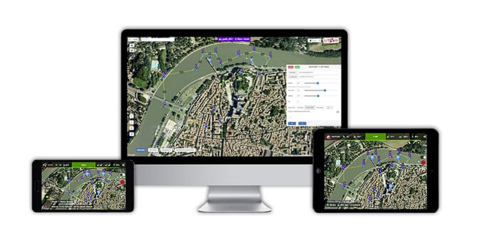
Its flight modes include Waypoints, Orbit, Follow, Track, Panorama, and VR. The best feature is Mission Hub, which lets you plan a flight on your computer at home. When you get to the location, the drone flies the path you drew, exactly, every time. That repeatability is what makes it so useful for real estate work and for returning to the same scene in different light.
The catch. Litchi for DJI Drones works with the Mini 2, Mini SE (version 1), Air 2S, Mavic Mini, Mavic Air 2, Mavic 2, Mavic Air, Mavic Pro, Phantom 3 and 4, Inspire 1 and 2, and Spark. If your drone is a Mini 3 or newer, this app will not connect to it. Litchi's replacement for those drones, Litchi Pilot, is still an open beta you download as an APK from Litchi's own forum rather than from an app store. It flies the Mini 3, Mini 3 Pro and Mini 4 Pro. It does not fly the Air 3, Mavic 3, Mavic 4 Pro or Mini 5 Pro, and there is no iPhone version at all, because DJI's current SDK has no iOS support.
So if you own an older DJI drone, Litchi is one of the best purchases you can make. It's a one-time payment, not a subscription. If you own a recent one, look at number 3 instead.
4. Aloft Air Control
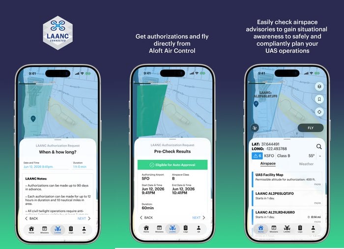
Air Control is the app this list used to recommend under a different name. It started life as Kittyhawk, the hobby pilot's flight-tracking app, and grew into the full compliance platform that Aloft runs today.
It handles the whole flight, start to finish. Pre-flight checklists, an airspace map with live advisories, LAANC authorization requests submitted from your phone, and an automatic logbook that records every flight you make. If you fly more than one drone, or fly with other people, it tracks the aircraft and the crew too.
That is more app than a casual flyer needs, which is why Air Aware sits at number 9 for the quick check. But if you're flying under Part 107, or you just want one place where your authorizations and your flight records live together, this is the one to install.
3. Dronelink
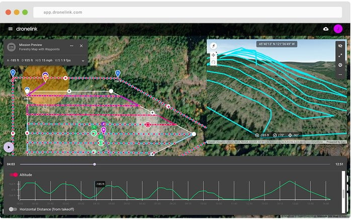
Dronelink is the mission planner to use if your drone is too new for Litchi.
You build the flight in a browser, dragging waypoints across a 3D map, and you can chain components together into one sequence. An orbit around a building, then a rise into a panorama, then a mapping grid, all in a single automated mission, with the camera doing what you told it to at every point. Terrain following keeps a constant height above sloping ground, which is what stops a hillside flight from drifting out of frame.
Support depends on your drone, and on your phone. The Mini 3, Mini 3 Pro and Mini 4 Pro fly from the app itself, on Android only, because DJI has no iOS build of the SDK those drones need. For the Air 3 series, the Mavic 3 series, the Mavic 4 Pro and the Inspire 3, you export the mission as a waypoint file and run it inside DJI Fly. It's a workaround, but it works, and it's the only route to complex automated missions on those drones.
It also reaches past DJI, which almost nothing else on this list does. The Matrice 4 and Anzu Raptor series are officially supported, and Autel's Evo II works unofficially.
It's a subscription rather than a one-time purchase. If you're shooting professionally, the planning time it saves pays for itself quickly.
2. PhotoPills
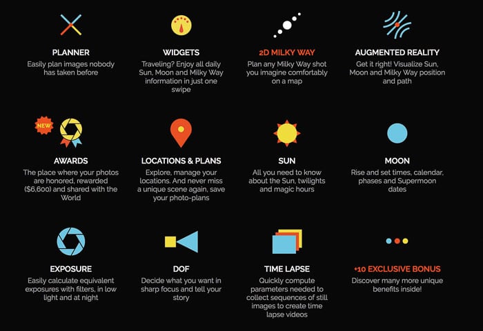
If I could only use one photography app, it would be PhotoPills. It has far too many features to cover here, but a lot of them are made for drone work.
The Planner and Sun pills let you see the movement, direction, and angle of the sun at any time on any date. So you can plan a sunrise or sunset shot before you leave the house, and know how much light you'll have when you get there.
The Planner also includes Drone View, which shows you what your composition will look like from a given altitude. Being able to check a shot from 300 feet without leaving your desk is the single biggest time-saver in drone photography.
It's a paid app, and worth every penny. It is not a quick answer, though. If all you want to know is whether tomorrow is flyable, UAV Forecast at number 6 tells you faster.
1. DJI Fly
If you're a recreational drone pilot, there's a good chance you're flying a drone made by DJI. DJI Fly is the app that flies it, and it takes the top spot for a reason that didn't exist a few years ago.
DJI has kept its Mobile SDK away from most of its recent consumer drones. On an Air 3, Air 3S, Mavic 3, Mavic 4 Pro, Flip, Neo or Mini 5 Pro, DJI Fly is not one option among several. It is the only app that connects to the aircraft, and even the missions you plan in Dronelink have to be flown inside it.
The Mini 3, Mini 3 Pro and Mini 4 Pro are the exception. Dronelink and Litchi Pilot both fly those three, on Android, and that is the whole of the third-party choice you get on a current DJI drone.
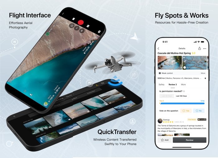
Luckily it's good. You get the live HD feed, full manual camera control including 10-bit D-Log M on the drones that shoot it, the intelligent flight modes, MasterShots and QuickShots, GEO airspace warnings before you take off, and QuickTransfer to pull full-resolution files onto your phone without a cable. There's a competent editor built in for a quick cut before you've left the field.
It replaced DJI GO and DJI GO 4, which only ever worked with the Phantom, Inspire, and early Mavic drones. If you're still running one of those, DJI GO 4 is the app you need, and it is still on the App Store. On Android you have to download it from DJI's own site, because DJI's drone apps are not on Google Play at all. For everything DJI has released since, it's DJI Fly.
It's free, and you already need it. Get to know what it can do.
Frequently Asked Questions
Do I Need an App to Fly a Drone Legally?
You don't have to install any particular app. What you do have to do in the US is get the authorization: flying in controlled airspace without a LAANC approval is not legal, and LAANC only comes through an FAA-approved supplier. The FAA retired its own B4UFLY app and now approves five companies to provide that service instead. AutoPylot at number 8 and Aloft at numbers 9 and 4 are two of them.
Which Drone App Handles LAANC Authorization?
AutoPylot and Aloft Air Control both do, and both are FAA-approved suppliers. Pick AutoPylot if you want one free app that covers the whole recreational job. Pick Air Control if you fly under Part 107, run more than one aircraft, or want your authorizations and your flight logs in the same place.
Can I Use a Third-Party Flight App With a New DJI Drone?
Only on some models. The Mini 3, Mini 3 Pro and Mini 4 Pro fly from Dronelink or Litchi Pilot, on Android. On the Air 3, Air 3S, Mavic 3, Mavic 4 Pro, Flip, Neo and Mini 5 Pro, DJI Fly is the only app that connects, so the workflow is to plan the mission in Dronelink and export it as a waypoint file to fly inside DJI Fly.
Are Drone Apps Free?
Most of this list is. DJI Fly, AutoPylot, Aloft Air Aware, Aloft Air Control and Google Maps are free, and Airdata UAV and UAV Forecast are free with paid tiers on top. The exceptions are Litchi, a one-time purchase, PhotoPills, a paid app, and Dronelink, whose free app flies manually but needs a plan for automated missions.
What Are Your Favorite Drone Camera Apps?
This is by no means an exhaustive list. There are so many great apps to help drone pilots fly well and take great photos and video.
The one thing worth repeating is to check compatibility before you pay for anything. The gap between what an app store listing promises and which drones an app actually connects to is where most of the money in this category gets wasted.
I always love to try new apps out, whether that's on iPhone or Android. So let me know in the comments what your favorites are. And if you want more inspiration for what to point your drone at, our roundup of influential aerial photographers is a good place to start.
Looking for more great tips for drone photography? Check out our post on the 3 Best Drones for Photography next!
