The hard part of landscape photography is rarely the camera work. It is knowing where to stand, and what time to be standing there. That is what every app on this list does.
These 12 are each the best at one job: timing an eclipse, finding the Milky Way, forecasting fog, reading the tide, or navigating off-trail in the dark. Work out which of those is costing you shots, then take the app that solves it. Most landscape photographers end up running three or four of them together.
Best Apps for Landscape Photographers
If you only install one, make it Google Earth. Scouting a location from your desk kills more wasted trips than any other tool here. The other 11 each solve a problem it cannot.
Time and Date
This website has a host of features that make it the best for landscape photographers during an eclipse. I have yet to find any dedicated landscape app for either Android or iOS that is so feature-rich.
Time and Date offers an ephemeris for any place in the world in handy to use calendar tables. I primarily use this website for planning lunar and solar eclipses many years in advance.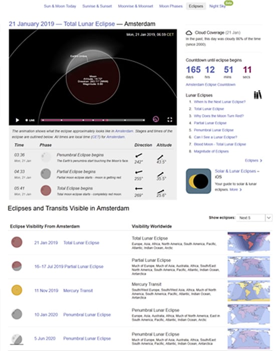
The best time to enjoy a Blood Moon, or indeed any full Moon, is after the moonrise when the Moon is close to the horizon. Before moonset is also a good time.
When the Moon is near the horizon, it looks bigger and brighter than when it’s high up in the sky. This is called the Moon illusion, and it played a part in the idea behind the Blood Moon shot below.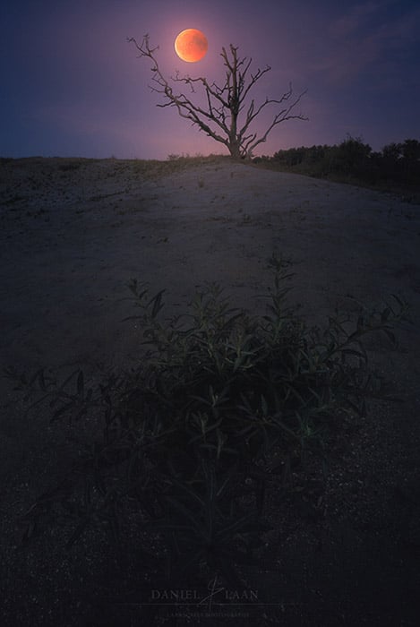
I saw the eclipse path on TimeAndDate.com. That means I knew that the eclipse had already reached totality when the Moon rose. And that the fully eclipsed Blood Moon would rise in the east.
So I put myself in a familiar area with a clear view of the eastern horizon and a bit of a foreground. But there was a big band of clouds blocking the moonrise.
TimeAndDate.com gave me the exact time I needed. Between the moment I observed the Moon slide out from the cloud cover at 22:50 and the end of totality at 23:13 local time.
This eclipse might have been the longest in over a century, but I was in quite a hurry. I ended up taking a wide-angle shot of sea buckthorn for the foreground. Then I combined it with a telephoto shot of the Blood Moon to dramatize the end result.
But there was one key part missing in planning this shoot: The exact point on the horizon where the Moon would rise. I use another app for Android for exactly this.
Sun Surveyor (and PhotoPills)
These are the best apps for knowing when the Sun and Moon rise. Both photography apps have more or less the same feature set and run on iOS and Android. Both are paid, at around $10 each as a one-off, and Sun Surveyor also has a free Lite version if you want to try the idea before you commit.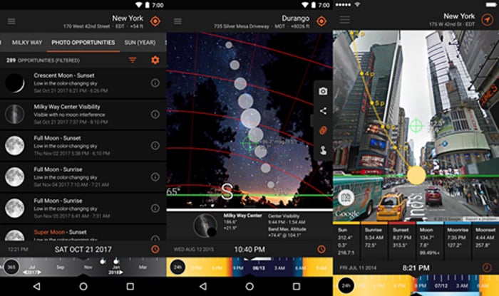
There's a map with your geographic location and the direction of the Sun, Moon, and even the Milky Way center. But there's also a live-view augmented reality feature.
Live-view in Sun Surveyor shows you an overlay of the path a celestial object follows along the sky. You can drag the time to the past or future. This means you can see where the Sun will rise, for instance. That's fantastic if you want the sun in a very specific area in your photo.
Sun Surveyor is one of the all-around best landscape apps out there. But actually, I find it most useful when planning nightscapes. At my resident latitude, the Milky Way is most visible during very particular dates and specific times during the day.
I used Sun Surveyor at the beach for the tracked Milky Way shot below. But I used the app about a year in advance. You can use PhotoPills to plan ahead for your backcountry shoots at any location in the world.
Here is our full review of PhotoPills.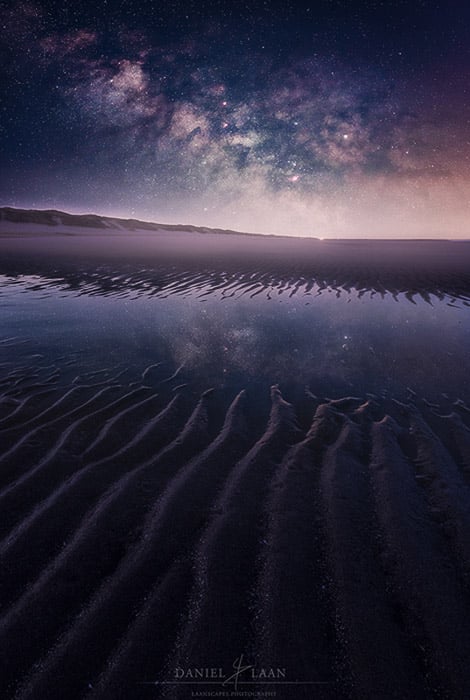
Stellarium
The best landscape app for night photography is Stellarium. There is an iOS version and an Android app. But it’s the open-source desktop application that I will discuss here.
Stellarium started out as an open-source program for PCs. With Stellarium, you can see the constellations, the planets, the Moon, and the Milky Way. What makes it the best is that there are add-ons.
These plugins enable you to see anything from meteor showers to satellites. That includes the International Space Station.
It is the go-to app for night sky enthusiasts. It’s also an invaluable addition to your collection of landscape photography apps. If you see a bright object and don’t know what it is, Stellarium will tell you.
You get a host of options from planning your nightscape photos in advance through the desktop application. And you get the 3D compass in the field when using the app. You can even turn the screen red to save your night vision.
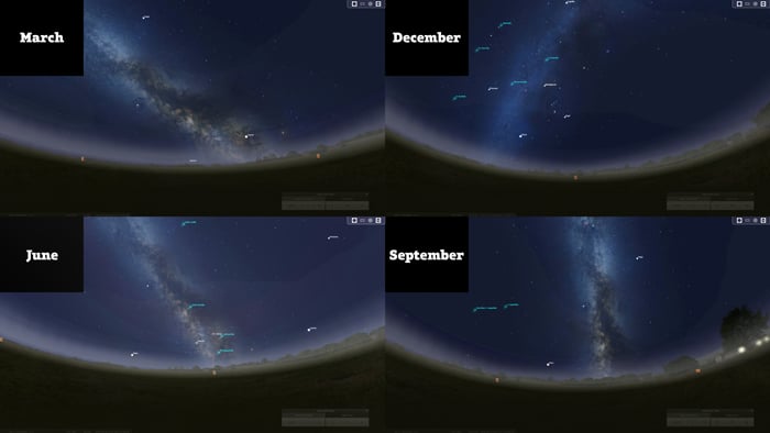
I like how Stellarium illustrates how the view of the Milky Way changes throughout the seasons. This helps a great deal when pinpointing those precious few days in more northern latitudes.
meteoblue
The weather is tough to forecast. As a landscape photographer, that's both frustrating and interesting, especially when you plan to capture the stars.
The best app for finding starry nights is meteoblue. There's a chart that I used to plan nightscapes up to three days in advance. I started that as soon as Stellarium pointed me to a moonless night.
The astronomical seeing chart is not easy to use, but it does provide information I can't find anywhere else. This includes air quality for seeing stars and other astronomical objects in the night sky. This can be found in the “Seeing” column below.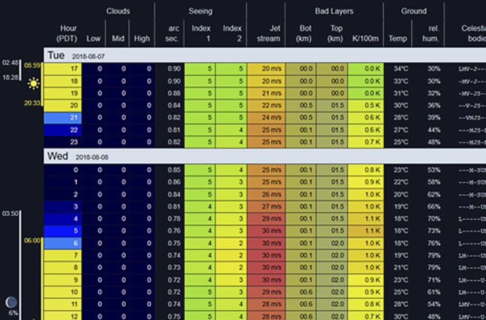
Without making it too complicated: “Seeing” is an index on a scale that runs from one through five.
Seeing five indicates the best conditions. You’ll see many more stars than when the seeing reading is at a measly one or two.
This chart is location-based and works anywhere on Earth.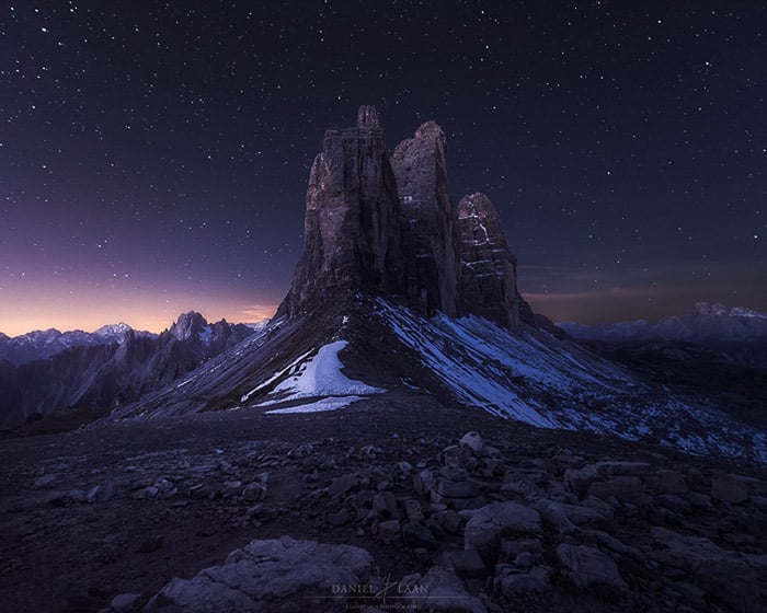
ISS Detector
If you want to further get into niches in landscape photography, we’ve got you covered. I'm guessing you want to know if there's something interesting to see apart from the Milky Way.
Sure, there are the Orion constellation and the Perseid meteor shower. But what if you wanted to do a group photo with a bunch of astronauts 400 kilometers away?
In that case, the best app for finding the International Space Station is ISS Detector.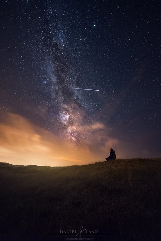
The International Space Station is orbiting our planet at 17,200 miles per hour. A sighting typically lasts for less than 4 minutes.
The station is also the brightest manmade object in the sky. After the Sun and the Moon, nothing you see up there is brighter.
Sunlight bouncing off its solar arrays means a high overhead pass will outshine Venus. That is bright enough to register in a wide-angle frame, and it is a good reason to have the tripod set up before the pass rather than during it.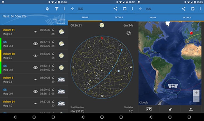
ISS Detector comes with all the necessary forecasting tools. It even has radar to see where and when the station appears. But there's much more orbiting the Earth than the International Space Station. You can use it to find Hubble, the Iridium constellation, and even comets.
It’s easy to set up and powerful enough to be used by professionals.
Weather Underground
Getting the right weather is a big part of landscape photography. And Weather Underground is the best app for the most accurate weather forecasts.
With Weather Underground, you can build a custom forecast. You can base it on a number of parameters, such as air pressure, relative humidity, temperature, wind speed, and location. By setting this up, I have a forecast ready for just about any photo opportunity.
The "foggy forest" forecast that I set up uses a relative humidity of anything above 90 percent and low wind speeds. It applies to just a particular area that I like to visit in the hours before dawn. And it works!
Weather Underground gives you notifications, a clear user interface, and dozens of features that you can actually use in planning your landscape photography. 
Estofex
Some landscape photographers love including extreme weather in their photos. This app is for the budding storm chasers.
Estofex is the acronym for the European Storm Forecast Experiment. And it’s the best free source of severe weather outlooks in Europe.
Volunteer forecasters issue storm outlooks covering lightning, hail, severe wind gusts, and tornadoes. One thing to know before you rely on it: the project is unfunded and carries no advertising, and it now states on its own forecast page that it cannot currently provide a daily service. Treat a fresh outlook as a bonus, not as something you can plan a week around.
There are three levels of severe (dangerous) weather within 40 kilometers of a point. A level one hazard is a 5% chance of severe weather. At level two, that chance is 15%. Level three is a 15% chance for extremely severe weather.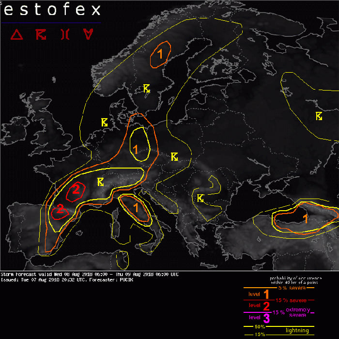
Using Estofex well for photography is a bit of a gamble. That’s partly because the exact location of a beautiful storm can be hard to forecast. I’ve had many misses when using this service. But I’ve also had some fantastic cloud formations as a result.
The purpose of this website is not to announce an opportunity for landscape photographers. Estofex isn’t a landscape photo app. The service warns forecasters and the public about dangerous weather, and your national weather service stays the official source of warnings where you live.
But here's why I still see it as one of the best landscape apps. Say there's a level one warning within 100 km of my location. That means I'm driving to the area to see if it’s a photogenic storm.
If there's a level two, I'm more cautious. I will drive to the edge of that area but only leave the car if I feel it’s safe. Remember, always err on the side of caution when it comes to Mother Nature.
Space Weather Live
There's another kind of storm worth chasing, and that's the geomagnetic kind. With Space Weather Live, forecasting the Northern Lights has never been easier.
With so many apps out there that tell you if there's going to be green in the sky tonight, it's tough to find the cream of the crop. I'm not using a native app at all. Instead, I'm going over to Space Weather Live for the forecast.
You’ll find 10-day sunspot forecasts and more. You’ll also find the answer to a simple photography question, “Is the aurora visible right now?”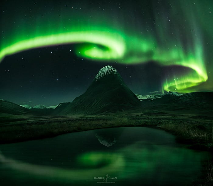
The northern lights and southern lights are a natural phenomenon. The aurora occurs because of charged solar particles that interact with the Earth's magnetic field.
The Sun is more active on certain days than on others. And as a result, the chances for the aurora can be higher. There is, of course, much more to this. But Space Weather Live gives you clear answers to your questions based on very complicated data.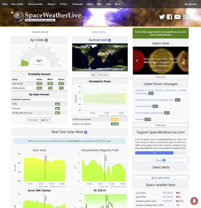
Gaia GPS
The best app for navigating rough terrain is Gaia GPS. Landscape work pulls you off marked trails and brings you back down them after dark. Add fog on a sunset shoot in the mountains and ground you don't know, and a phone that can still plot your exact position stops being a convenience.
What earns it the place over a general hiking app is the map catalogue. You stack layers rather than pick one: topographic, satellite, slope angle, public land boundaries, even historical imagery. Two of those answer questions worth settling before you commit to a hike, namely how steep the approach really is, and whether you are allowed to be standing there at all.
It reads GPX and KML files, so a route you plotted at home in Google Earth transfers to the phone as an overlay. It records your own track as you walk, which is how you find the same overlook again next season. And it syncs with the browser app, so the planning doesn't have to happen on a phone screen.
The honest catch is the paywall, and it sits on the one feature you most need. Downloading maps for offline use takes a paid membership, so the free tier is the version that fails you in exactly the place you installed it for, which is a valley with no bars. You also have to make an Outside account before the app will open, because Gaia GPS is part of the Outside Network now.
So buy the membership and pull your map downloads at home, on wifi, the night before. Finding out at the trailhead that your maps live in the cloud is a bad way to learn this.
Monumental Trees
You can find everything online these days. Even the girth of trees around the globe. Monumental Trees is a huge database of the most stunning trees that are still around.
The register runs to more than 16,000 trees with over 40,000 photos between them, and members add new finds every week. They range from a couple of meters of girth to giants over 30 meters in circumference.
The website features an interactive map. This helps you explore the area digitally before heading out to the forest for some tree photography. Beech trees and oaks are my personal favorites.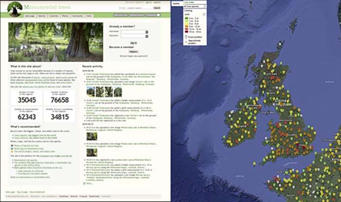
Tides Near Me
Seascapes are as timeless as the sea itself. Even the most empty, zen-like imagery contains some type of subject.
The best time for seascape photography isn't always sunrise or blue hour. It’s about the time when the tide is receding.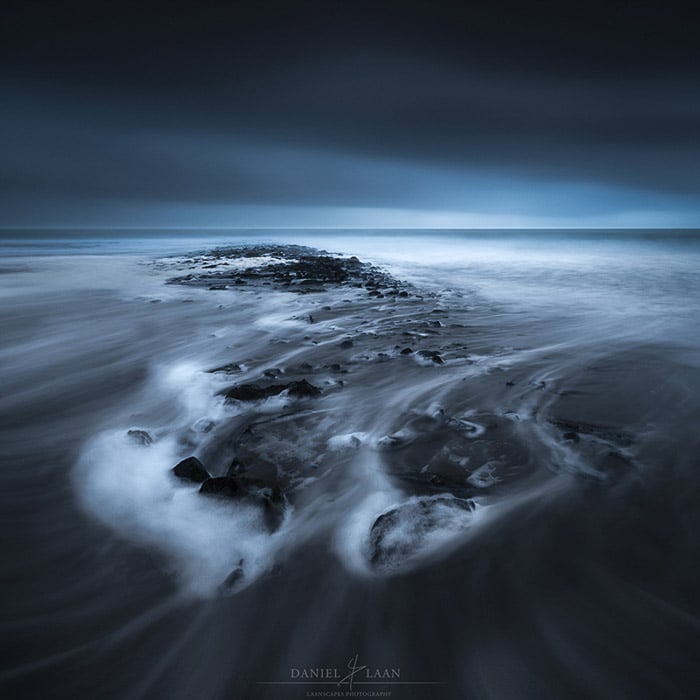
The receding tide has a number of benefits as opposed to high tide. Most importantly, footsteps are erased. Your rocky subjects in the sand will be adorned in nice foamy stretches. Especially with long exposure shots.
So when is the tide receding? Tides Near Me answers that in one screen, and it is free on both iOS and Android. It reads the last and next tide at a glance, with tide tables and current predictions for stations worldwide.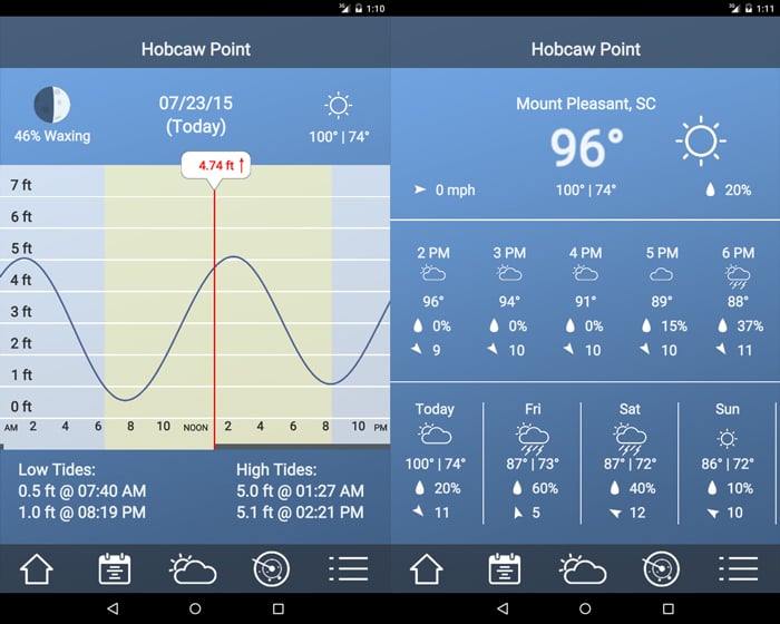
You're looking for a moment when you're at the edge of the water. Notice the point where the graph is coming down again. That’s when the tide is heading out, which is the time you’re aiming for.
It covers tide stations anywhere in the world, which is what you want if you travel to shoot. It also prints sun and moon rise and set times next to the tide, so you can line up a receding tide with the light in the same glance.
One limit worth knowing: it is a tide app, not a weather app. It will not tell you whether the cloud is going to break, so pair it with Weather Underground or meteoblue above. And on a coast with few gauges, the nearest station can sit some way from your actual beach, so check which one it picked before you trust the timing to the minute.
Google Earth
This one doesn't need much introduction. Google Earth is the first app that I used for landscape photography and I still use it today. It’s the best overall app for landscape photography.
You can plan your next shoot halfway across the planet with Google Earth. You can virtually scout the area before you spend time, money, and effort to discover that it isn't worth it.
To me, Google Earth is just as good at eliminating locations as selecting them. So when you have limited time, you can make sure that it's well spent.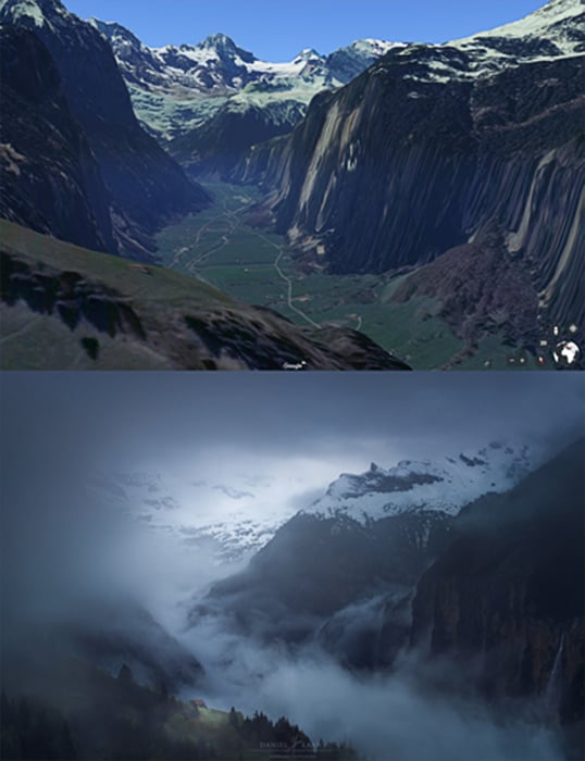
I use both street view and the built-in 3D functionalities. These give me an idea of my position relative to my surroundings.
It has gone through some changes over the years, and the web version now runs in any modern browser rather than Chrome alone. Google Earth is fast, accurate, and free everywhere. It’s definitely been at the top of my list of best landscape apps for a long time.
The one thing it won't do is tell you about light. It shows you the shape of a place, not when the sun hits it, so pair it with Sun Surveyor or PhotoPills before you set an alarm.
Frequently Asked Questions
What is the best app for landscape photography?
Google Earth is the best all-round pick, because scouting a location before you drive to it saves more time than any other tool on this list. For light, Sun Surveyor and PhotoPills are the two worth paying for. No single app does both jobs well, which is why most landscape photographers run two or three together.
Do I need to pay for landscape photography apps?
Most of this list is free. Google Earth, Stellarium, Time and Date, meteoblue, Space Weather Live, Estofex, Monumental Trees, and Tides Near Me all cost nothing. The paid exceptions are Sun Surveyor and PhotoPills, and Gaia GPS, whose offline map downloads sit behind a membership. Start free and only pay once you know which job you keep repeating.
Which app tells me where the sun will rise?
Sun Surveyor and PhotoPills both do, and both show the path as an augmented-reality overlay through the phone camera so you can stand in the spot and see where the light will land. Time and Date covers the same ground for eclipses specifically, further ahead than either app plans.
What app should I use to find the Milky Way?
Stellarium for identifying what is in the sky, and Sun Surveyor or PhotoPills for working out when the core is above your horizon. Add meteoblue's seeing forecast to check the air is clear enough to be worth the drive. Our guide to photographing the Milky Way covers the camera settings once you get there.
Do these apps work without a phone signal?
Some do and some don't, and it matters more than any other feature. Stellarium, Sun Surveyor, and PhotoPills calculate positions on the device, so they keep working in a dead spot. Anything reading live data, which means the weather apps, Space Weather Live, and the tide stations, needs a connection. Gaia GPS works offline only if you download the maps first, on a paid membership.
Conclusion: Best Apps for Landscape Photography
You do not need all 12. Pick the one that fixes the shot you keep missing: Google Earth if you turn up at locations that disappoint, Sun Surveyor or PhotoPills if the light is never where you expected, Weather Underground or meteoblue if you keep driving out to cloud, and Gaia GPS if getting back down in the dark is the part that worries you.
Install that one this week and use it to plan a single shoot properly. Then add the next. The apps that stay on your phone are the ones that earned their place on a real trip, and you'll work out which those are faster than any list can tell you.